
Black Hills National Forest Hand-Drawn Map Print by Xplorer Maps
$24.99
In stock
Shipping calculated in cart/checkout: Shipping rates for first items start at $7, calculated based on weight of total order.
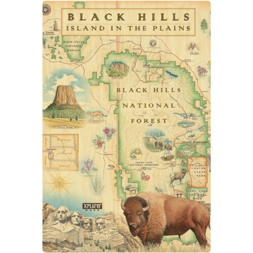
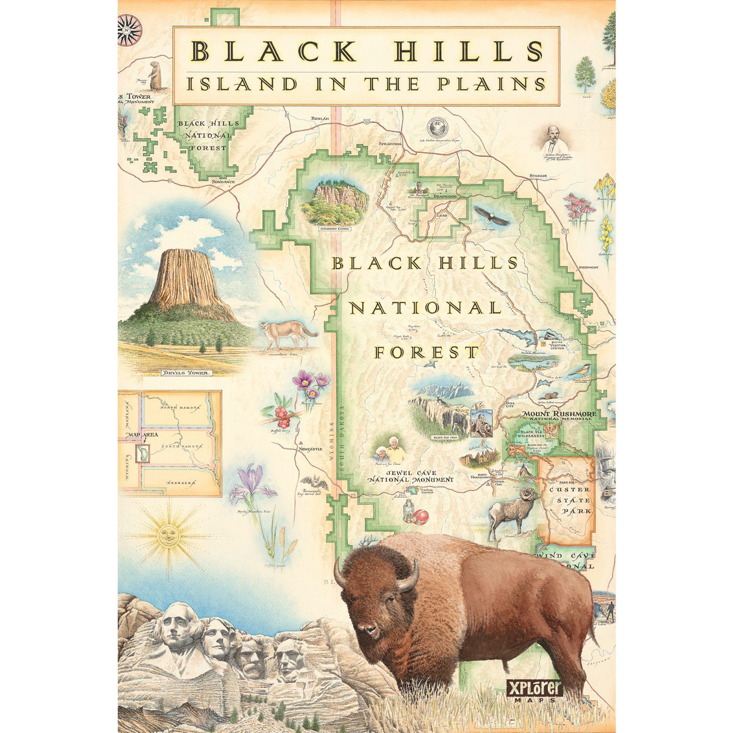
An 18″ x 24″ hand-illustrated map of the Black Hills, drawn in pen and ink with watercolor by Xplorer Maps artist Chris Robitaille. The design covers Black Hills National Forest and the surrounding region, with landmarks, wildlife, and typography rendered by hand throughout.
- 18″ x 24″ poster format, ships rolled in a protective tube (approx. 19″ x 2.5″ diameter)
- Hand-illustrated art print in pen and ink with watercolor, not a cartographic or photographic reproduction
- Covers Black Hills National Forest, Spearfish Canyon, the George S. Mickelson Trail, and surrounding public lands
- Wildlife depicted: bison, elk, mountain goats, and bald eagles
- Proceeds support the Black Hills National Forest and other BHPFA partner parks and forests
In stock
60-day returns · Ships from South Dakota via USPS
Black Hills National Forest Hand-Drawn Map Print by Xplorer Maps
$24.99
In stock
Shipping calculated in cart/checkout: Shipping rates for first items start at $7, calculated based on weight of total order.
An 18″ x 24″ hand-illustrated map of the Black Hills, drawn in pen and ink with watercolor by Xplorer Maps artist Chris Robitaille. The design covers Black Hills National Forest and the surrounding region, with landmarks, wildlife, and typography rendered by hand throughout.
- 18″ x 24″ poster format, ships rolled in a protective tube (approx. 19″ x 2.5″ diameter)
- Hand-illustrated art print in pen and ink with watercolor, not a cartographic or photographic reproduction
- Covers Black Hills National Forest, Spearfish Canyon, the George S. Mickelson Trail, and surrounding public lands
- Wildlife depicted: bison, elk, mountain goats, and bald eagles
- Proceeds support the Black Hills National Forest and other BHPFA partner parks and forests
In stock
60-day returns · Ships from South Dakota via USPS
Real USPS rates, no markup. The money we save funds trail crews and internships.
Join BHPFA for $30 a year -> get your code by email in seconds. -> Use it at checkout today. Show your card at hundreds of nonprofit park stores nationwide for 10% off.
Every item is selected or approved by rangers and staff. Your purchase keeps them on the front lines.
Real USPS rates, no markup. The money we save funds trail crews and internships.
Join BHPFA for $30 a year -> get your code by email in seconds. -> Use it at checkout today. Show your card at hundreds of nonprofit park stores nationwide for 10% off.
Every item is selected or approved by rangers and staff. Your purchase keeps them on the front lines.
Description
What is this print?
This is an 18″ x 24″ hand-illustrated map of the Black Hills region produced by Xplorer Maps, a map art company based in Missoula, Montana. Artist Chris Robitaille drew the original design in pen and ink with watercolor. It is not a topographic map or a satellite image. It is an illustrated art print that uses the map format to show the geography, wildlife, and character of the Black Hills.
The composition covers Black Hills National Forest across western South Dakota, with Spearfish Canyon, the George S. Mickelson Trail, and the wider Black Hills region shown in detail. Robitaille works illustrations of native wildlife into the geography: bison, elk, mountain goats, and bald eagles appear throughout the design. Cultural and historic landmarks including historic Deadwood are also rendered by hand.
Xplorer Maps produces illustrated map prints for national parks, forests, and regions across the country. Each design goes through the same hand-drawn process, which is why the prints read as art rather than navigation tools. This one is sold through BHPFA’s park stores to support Black Hills National Forest and BHPFA’s other partner sites.
Specifications
- Print dimensions: 18″ x 24″
- Packaged dimensions: approx. 19″ x 2.5″ diameter (rolled in tube)
- Weight: 6.3 oz (packaged)
- Print type: Fine art lithograph (hand-illustrated original)
- Subject area: Black Hills National Forest, South Dakota and Wyoming
- Artist: Chris Robitaille, co-founder of Xplorer Maps
- Manufacturer: Xplorer Maps, Missoula MT
- Sold unframed
What’s shown on the map
The print covers the Black Hills region of western South Dakota, centered on Black Hills National Forest. Key features illustrated on the map include:
- Black Hills National Forest (approximately 1.25 million acres across South Dakota and Wyoming)
- Spearfish Canyon, a 19-mile canyon in the northern Black Hills known for limestone walls and waterfalls
- The George S. Mickelson Trail, a 109-mile rail-trail running the length of the Black Hills
- Historic Deadwood, a National Historic Landmark district in the northern Black Hills
- Regional wildlife including bison, elk, mountain goats, and bald eagles
The design also shows the regional landscape context: the transition from Black Hills ponderosa pine forest to the surrounding plains, major roads and communities, and surrounding public lands.
Who is this for?
People who want Black Hills art that does something a landscape photograph doesn’t. The map format gives it a practical-feeling anchor, but the hand-drawn style means it reads as a piece of art, not a navigation aid. It works in a living room, a cabin, a forest service visitor center, or an office.
It also works as a gift for people with a specific connection to the Black Hills. The detail level is high enough that someone who knows the region will recognize places and spend time looking at it.
At 18″ x 24″, this fits standard poster frames. Standard frames at this size are widely available and reasonably priced, though the print ships unframed.
About Black Hills National Forest
Black Hills National Forest is a US Forest Service unit covering approximately 1.25 million acres across western South Dakota and northeastern Wyoming. It surrounds and connects several other public land units in the region. Black Elk Peak, the highest point in South Dakota and the Black Hills at 7,242 feet, is within the forest, renamed from Harney Peak in 2016. The forest also includes Pactola Reservoir, Sylvan Lake, and Spearfish Canyon.
BHPFA (Black Hills Parks and Forests Association) is the official nonprofit partner for Black Hills National Forest, providing educational materials, retail operations at visitor facilities, and funding for forest programs. A portion of every purchase at BHPFA park stores goes directly back to supporting the forest.
Frequently asked questions
What size is this print?
18″ x 24″. It ships rolled in a protective tube. Standard poster frames in this size are widely available at home goods stores. The print is sold unframed.
Is this a topographic map or a navigation map?
No. This is a hand-illustrated art print that uses the map format as a design structure. It is not suitable for trail navigation. For topographic hiking maps of the Black Hills, see the National Geographic Trails Illustrated maps available elsewhere in the store.
What is the print format?
Fine art lithograph, based on an original hand-illustrated design in pen and ink with watercolor by Chris Robitaille of Xplorer Maps. It is a printed reproduction of the original hand-drawn artwork.
Does buying this support Black Hills National Forest?
Yes. BHPFA is the official nonprofit partner of Wind Cave National Park, Jewel Cave National Monument, Scotts Bluff National Monument, and Agate Fossil Beds National Monument, as well as the Black Hills National Forest and Nebraska National Forests and Grasslands. Proceeds from every purchase support education programs, conservation projects, and visitor services at these sites.
Is this sold at BHPFA park store locations?
Yes. This print is available through BHPFA’s retail operations serving Black Hills National Forest and Wind Cave National Park. Availability at specific locations may vary by season; call ahead for in-store availability.
Can I get this framed?
The print ships unframed. Standard 18″ x 24″ poster frames are widely available. Because the print ships rolled, it may need a day or two to flatten under weight before framing.
Are there other Xplorer Maps products available?
Xplorer Maps produces illustrated map art for many national parks and forests. Check the full store for other BHPFA partner site designs.
Every Purchase Makes a Difference
When you shop with Black Hills Parks & Forests Association, you are directly funding:
- Education programs — nature workshops, Junior Ranger activities, and homeschool adventures for kids across the Black Hills
- Trail maintenance — keeping hiking trails safe and accessible at Wind Cave, Jewel Cave, and the Black Hills National Forest
- Visitor services — park store operations, interpretive programs, and the staff who help millions of visitors each year
- Conservation — supporting the long-term health of public lands in the Black Hills and Nebraska
BHPFA is the official nonprofit partner of the National Park Service and U.S. Forest Service in the Black Hills region. We have supported these public lands since 1946.
Additional information
| Weight | 15 oz |
|---|---|
| Brand | Xplorer Maps |
| Dimensions | 18" x 24" (print); 19" x 2.5" dia. (packaged) |
| Weight | 6.3 oz |
| Material | Fine art lithograph print on paper |
Note on International Orders
Some countries charge import duties, VAT, or handling fees on delivery. These are set by your local government and are not included in our checkout total. Customers are responsible for paying any such charges before receiving their package.