Description
What is this poster?
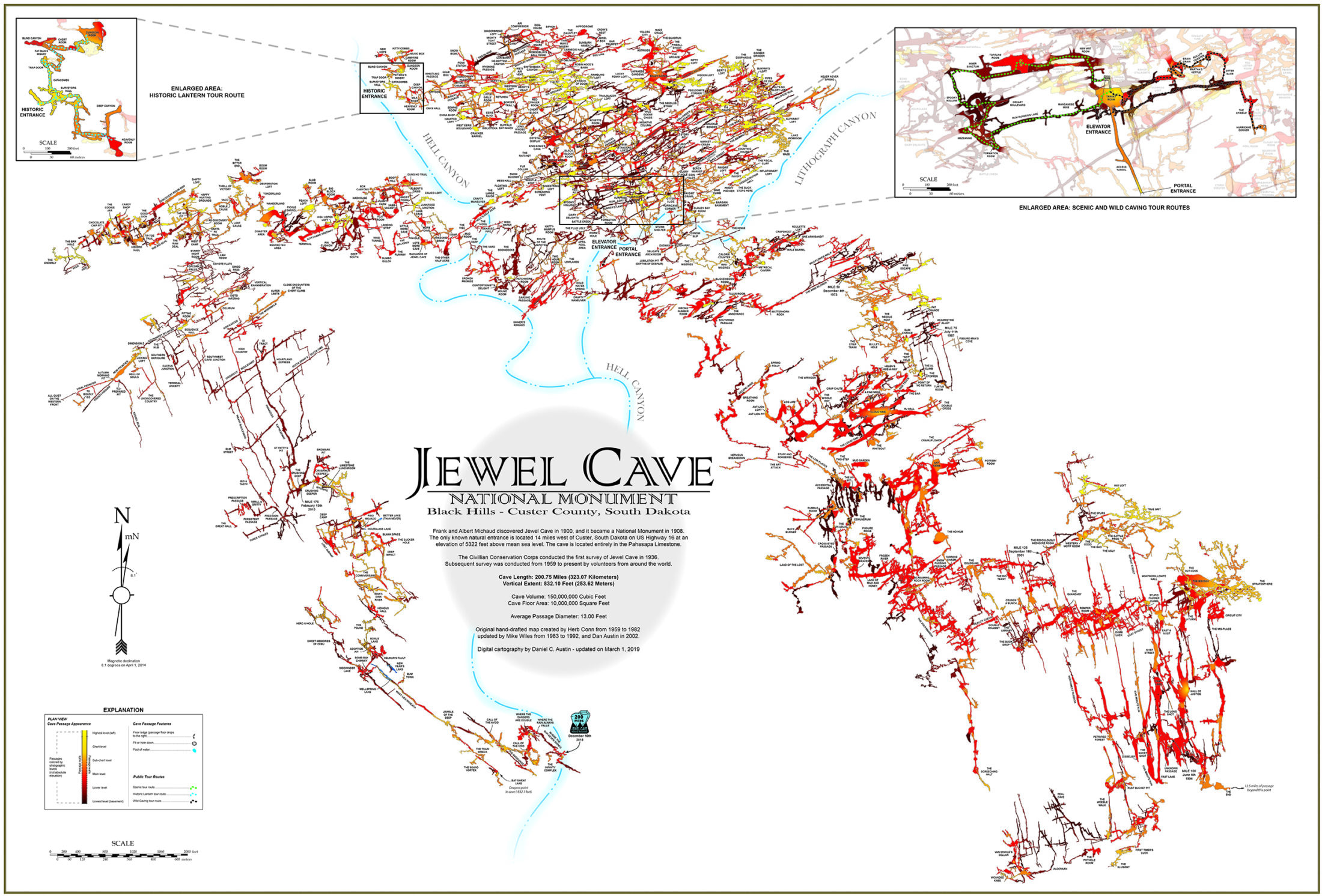
It is a cartographic print of the Jewel Cave passage network, showing every surveyed mile of the cave system as of February 2024. The cave exists within Pahasapa Limestone in the Black Hills of South Dakota, and this map traces its layout across 219.66 miles of documented passage. Jewel Cave is the third-longest cave in the world, after Mammoth Cave in Kentucky and Sistema Sac Actun in Mexico.
The cartography on this poster has a direct lineage to the people who physically explored the cave. Herb Conn, part of a husband-and-wife climbing team that began systematic exploration in 1959, hand-drafted the original maps through 1982. Mike Wiles continued that work from 1983 to 2002. Dan Austin brought it into digital form from 2009 to 2023, and Chris Pelczarski carried the digital cartography through 2024. The map is not an approximation; it follows the survey team’s own measurements.
The cave was discovered in 1900, when brothers Frank and Albert Michaud noticed wind rushing from a small opening in the Black Hills. The National Monument was established by Theodore Roosevelt in 1908. The first formal survey came through the Civilian Conservation Corps in 1936. By 1959, less than 2 miles had been mapped. The systematic survey that produced this poster’s level of detail began when the Conns took up the work that year.
What the map shows
The poster displays the full passage network as it was surveyed through February 2024, at a scale that fits 24 inches wide by 18 inches tall. The cave lies entirely within Pahasapa Limestone. Notable geological features include calcite crystals (dogtooth spar and nailhead spar, for which the cave is named), boxwork formations, cave popcorn, flowstone, and calcite ribbon known as “cave bacon.”
The passage network is color-coded and labeled to show the cave’s structure. The Splinter Section, a breakthrough discovery in 2014 that added over 24 miles to the survey in a short period, is part of the map. On December 15, 2018, a six-person survey team crossed 200 miles in a single night, ending at 200.3 miles. The February 2024 figure on this poster reflects continued growth since then.
Specifications
- Dimensions: 24″ wide x 18″ tall
- Weight: 12 oz
- Subject: Jewel Cave National Monument passage network
- Survey date shown: February 2024 (219.66 miles / 353.51 km)
- Original cartography: Herb Conn (1959-1982)
- Additional hand-drafting: Mike Wiles (1983-2002)
- Digital cartography: Dan Austin (2009-2023), Chris Pelczarski (2023-2024)
- Location: Jewel Cave National Monument, 11149 US-16 Building B12, Custer SD 57730
Who is this for?
People who have toured Jewel Cave and want a physical record of what they walked through. The Scenic Tour, Historic Lantern Tour, and Wild Caving Tour each give you a small slice of the cave. This map puts that slice in context: 219 miles of passage that extends far beyond any single tour route.
Cave enthusiasts and geology readers who want something specific on the wall. This is not a generic park print. The cartography goes back to Herb Conn’s hand-drafted originals from 1959, and the line from those notebooks to the February 2024 digital file is direct.
Gift buyers looking for something tied to a real visit. If someone you know spent time at Jewel Cave, this poster connects to that experience in a way a generic souvenir does not.
Frequently asked questions
What does the map actually show?
The complete surveyed passage network of Jewel Cave National Monument as of February 2024, totaling 219.66 miles (353.51 kilometers). Passages are mapped within the Pahasapa Limestone formation. The cave continues to be surveyed; the factual total as of 2026 exceeds 220 miles, but the map reflects the February 2024 survey snapshot.
Who drew this map?
The cartography traces back to Herb Conn, who began hand-drafting the cave in 1959 alongside his wife Jan. The Conns added roughly 64 miles through the 1960s and 70s. Mike Wiles continued the hand-drafting work through 2002. Dan Austin converted and expanded the map digitally from 2009 to 2023. Chris Pelczarski updated the digital cartography through 2024. The February 2024 version on this poster is the current published edition.
Is this the official Jewel Cave map?
The map is produced from the official NPS and volunteer survey data. It is sold at Jewel Cave National Monument through the Black Hills Parks & Forests Association, the official nonprofit partner of the park. It is not a third-party approximation.
How long is Jewel Cave?
As of 2026, Jewel Cave has more than 220 surveyed miles, making it the third-longest cave in the world. The cave system grows by several miles in active survey years as the volunteer team continues mapping.
What cave formations are in Jewel Cave?
The cave is named for its calcite crystals: dogtooth spar (sharp, pointed) and nailhead spar (flat, blunt). Other formations include boxwork (a honeycomb-patterned calcite structure, the same type Wind Cave is known for), cave popcorn, flowstone, and a calcite ribbon called “cave bacon.”
Does buying this support Jewel Cave?
Yes. BHPFA is the official nonprofit partner of Wind Cave National Park, Jewel Cave National Monument, Scotts Bluff National Monument, and Agate Fossil Beds National Monument, as well as the Black Hills National Forest and Nebraska National Forests & Grasslands. Proceeds from every purchase support education programs, conservation projects, and visitor services at these sites.
What size is the poster?
24 inches wide by 18 inches tall. It fits standard 24″ x 18″ frames, which are widely available at frame shops and home goods stores.
Can I get a Passport stamp at Jewel Cave?
Yes. Jewel Cave National Monument has a Passport to Your National Parks cancellation stamp available at the visitor center. The four BHPFA partner NPS sites with Passport stamps are Wind Cave National Park, Jewel Cave National Monument, Scotts Bluff National Monument, and Agate Fossil Beds National Monument.
Related items
- Wind Cave National Park Map Poster ($12.99)
- All Jewel Cave products
- Hiking Centennial Trail ($25.99)