
Wind Cave National Park Map Poster
$12.99
In stock
Shipping calculated in cart/checkout: Shipping rates for first items start at $7, calculated based on weight of total order.
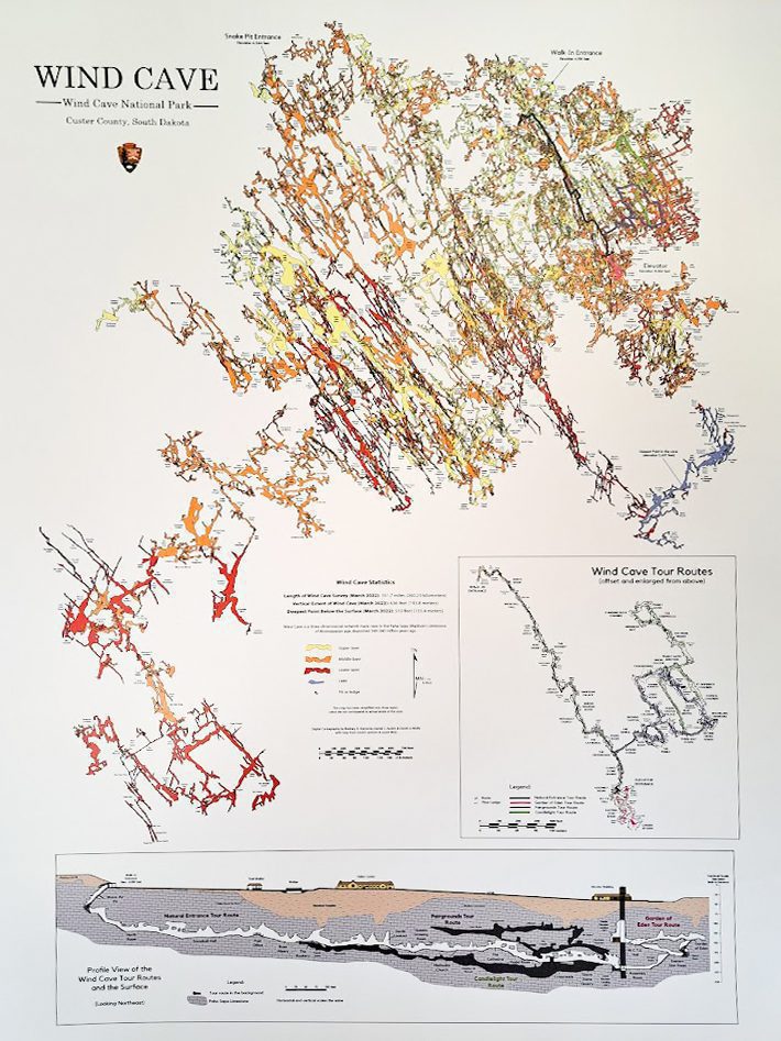
A full-color poster showing the surveyed cave passages at Wind Cave National Park, drafted by the NPS cartographers who mapped the cave. The map reflects 161.7 miles of surveyed passage as of the March 2022 digital update, including the boxwork-rich chambers Wind Cave is known for.
- Size: 18″ wide x 24″ tall
- Cartography: Rodney D. Horrocks, Daniel C. Austin, and Derek A. Wolfe (NPS), updated March 2022
- Subject: the complete Wind Cave passage network, 161.7 miles (260.23 km)
- Proceeds support Wind Cave National Park and other BHPFA partner parks and forests
- A good gift for cave explorers, geology enthusiasts, and anyone who has taken a Wind Cave tour
In stock
60-day returns · Ships from South Dakota via USPS
Wind Cave National Park Map Poster
$12.99
In stock
Shipping calculated in cart/checkout: Shipping rates for first items start at $7, calculated based on weight of total order.
A full-color poster showing the surveyed cave passages at Wind Cave National Park, drafted by the NPS cartographers who mapped the cave. The map reflects 161.7 miles of surveyed passage as of the March 2022 digital update, including the boxwork-rich chambers Wind Cave is known for.
- Size: 18″ wide x 24″ tall
- Cartography: Rodney D. Horrocks, Daniel C. Austin, and Derek A. Wolfe (NPS), updated March 2022
- Subject: the complete Wind Cave passage network, 161.7 miles (260.23 km)
- Proceeds support Wind Cave National Park and other BHPFA partner parks and forests
- A good gift for cave explorers, geology enthusiasts, and anyone who has taken a Wind Cave tour
In stock
60-day returns · Ships from South Dakota via USPS
Real USPS rates, no markup. The money we save funds trail crews and internships.
Join BHPFA for $30 a year -> get your code by email in seconds. -> Use it at checkout today. Show your card at hundreds of nonprofit park stores nationwide for 10% off.
Every item is selected or approved by rangers and staff. Your purchase keeps them on the front lines.
Real USPS rates, no markup. The money we save funds trail crews and internships.
Join BHPFA for $30 a year -> get your code by email in seconds. -> Use it at checkout today. Show your card at hundreds of nonprofit park stores nationwide for 10% off.
Every item is selected or approved by rangers and staff. Your purchase keeps them on the front lines.
Description
What is this poster?
It is a cartographic print of the Wind Cave passage network, showing every surveyed mile of the cave system as of the March 2022 digital update. The map traces 161.7 miles (260.23 kilometers) of passage in the southern Black Hills of South Dakota. Wind Cave is the seventh-longest cave in the world and the fourth-longest in the United States, and it contains an estimated 95% of the world’s known boxwork, the rare honeycomb-patterned calcite formation that defines the cave’s interior.
The cartography is the work of NPS cave specialists Rodney D. Horrocks, Daniel C. Austin, and Derek A. Wolfe. The map is not an artistic interpretation; it follows the survey team’s own measurements and reflects the cave as it has actually been documented passage by passage.
The cave was discovered in 1881, when brothers Tom and Jesse Bingham heard wind whistling out of a small hole in the ground. Wind Cave became the seventh national park in the United States on January 9, 1903, signed into law by Theodore Roosevelt. It was the first national park established specifically to protect a cave. The above-ground portion of the park covers mixed-grass prairie, ponderosa pine forest, and a free-roaming bison herd descended from 14 animals transferred from the Bronx Zoo in 1913, one of the earliest bison restoration herds in North America.
What the map shows
The poster displays the full surveyed passage network on a sheet measuring 18 inches wide by 24 inches tall. Wind Cave is famous for its density of boxwork, calcite fins that form a three-dimensional honeycomb pattern across cave walls and ceilings. Other formations include cave popcorn, frostwork, and helictites. The mapped passages occupy a relatively small footprint at the surface (roughly one square mile) but extend through three dimensions in a maze-like network of passages stacked on multiple levels.
The 161.7-mile figure on this poster reflects the March 2022 cartographic update. Wind Cave continues to be surveyed; the cave system has grown steadily as exploration teams document new passages. The poster captures a specific, dated snapshot of the surveyed cave.
Specifications
- Dimensions: 18″ wide x 24″ tall
- Weight: 12 oz
- Subject: Wind Cave National Park passage network
- Survey date shown: March 2022 (161.7 miles / 260.23 km)
- Cartography: Rodney D. Horrocks, Daniel C. Austin, Derek A. Wolfe (NPS)
- Location: Wind Cave National Park, 26611 US-385, Hot Springs SD 57747
Who is this for?
People who have toured Wind Cave and want a physical record of what they walked through. The Garden of Eden Tour, Natural Entrance Tour, Fairgrounds Tour, and Candlelight Tour each give you a small slice of the cave. This map puts that slice in context: 161.7 miles of passage that extends well beyond any single tour route.
Cave enthusiasts and geology readers who want something specific on the wall. Wind Cave’s boxwork is the densest documented anywhere in the world, and the map shows where in the system that geology lives. This is not a generic park print.
Gift buyers looking for something tied to a real visit. If someone you know spent time at Wind Cave, this poster connects to that experience in a way a generic souvenir does not.
Frequently asked questions
What does the map actually show?
The complete surveyed passage network of Wind Cave National Park as of the March 2022 update, totaling 161.7 miles (260.23 kilometers). The cave continues to be surveyed and the figure may grow in future editions; this poster reflects the March 2022 cartographic snapshot.
Who drew this map?
Cartography is by Rodney D. Horrocks, Daniel C. Austin, and Derek A. Wolfe. Horrocks is a long-time NPS physical scientist and cave specialist; Austin also worked on the digital cartography for the Jewel Cave map. The map is built from official NPS and volunteer survey data.
Is this the official Wind Cave map?
The map is produced from the official NPS survey data. It is sold at Wind Cave National Park through the Black Hills Parks & Forests Association, the official nonprofit partner of the park. It is not a third-party approximation.
How long is Wind Cave?
Approximately 161 miles surveyed, making it the seventh-longest cave in the world and the fourth-longest in the United States. The cave grows as the survey team continues mapping new passages.
What is boxwork?
Boxwork is a calcite formation that creates a honeycomb-like pattern of thin fins protruding from cave walls and ceilings. It forms when calcite veins fill cracks in the original limestone, then the surrounding limestone weathers away, leaving the harder calcite fins behind. Wind Cave contains an estimated 95% of the world’s known boxwork, by far the densest concentration anywhere. It is the cave’s defining geological feature.
Does buying this support Wind Cave?
Yes. BHPFA is the official nonprofit partner of Wind Cave National Park, Jewel Cave National Monument, Scotts Bluff National Monument, and Agate Fossil Beds National Monument, as well as the Black Hills National Forest and Nebraska National Forests & Grasslands. Proceeds from every purchase support education programs, conservation projects, and visitor services at these sites.
What size is the poster?
18 inches wide by 24 inches tall (portrait orientation). It fits standard 18″ x 24″ frames, which are widely available at frame shops and home goods stores.
Can I get a Passport stamp at Wind Cave?
Yes. Wind Cave National Park has a Passport to Your National Parks cancellation stamp available at the visitor center. The four BHPFA partner NPS sites with Passport stamps are Wind Cave National Park, Jewel Cave National Monument, Scotts Bluff National Monument, and Agate Fossil Beds National Monument.
Related items
- Jewel Cave National Monument Map Poster ($12.99)
- All Wind Cave products
- Scenic Highways Wind Cave Vintage Poster (different design, 14″ x 22″)
Every Purchase Makes a Difference
When you shop with Black Hills Parks & Forests Association, you are directly funding:
- Education programs — nature workshops, Junior Ranger activities, and homeschool adventures for kids across the Black Hills
- Trail maintenance — keeping hiking trails safe and accessible at Wind Cave, Jewel Cave, and the Black Hills National Forest
- Visitor services — park store operations, interpretive programs, and the staff who help millions of visitors each year
- Conservation — supporting the long-term health of public lands in the Black Hills and Nebraska
BHPFA is the official nonprofit partner of the National Park Service and U.S. Forest Service in the Black Hills region. We have supported these public lands since 1946.
Additional information
| Weight | 12 oz |
|---|---|
| Dimensions | 27 × 3.25 × 3.25 in |
| Brand | Black Hills Parks & Forests Association |
| Dimensions | 18" x 24" |
| Weight | 12 oz |
| Material | Paper |
| Publisher / Manufacturer | Black Hills Parks & Forests Association |
| Map Coverage Area | Wind Cave National Park, South Dakota |
Note on International Orders
Some countries charge import duties, VAT, or handling fees on delivery. These are set by your local government and are not included in our checkout total. Customers are responsible for paying any such charges before receiving their package.