The geology of Scotts Bluff: how a bluff outlived the plains
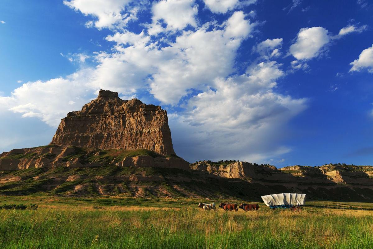
Scotts Bluff did not rise above the plains. The plains sank around it. What you are looking at is a survivor, 740 feet of stacked time that erosion has not yet erased.
Put your hand on the pale rock at the base of Scotts Bluff. It crumbles. Press a little and grains of 33-million-year-old volcanic ash come away on your fingers.
Now look straight up the cliff to the hard ledge at the top. That ledge is the one thing holding the whole bluff together. Soft below, hard above. That contrast is the entire story.
Here is the part that turns the view inside out. The bluff is not growing. It has spent the last several million years getting smaller, just slower than everything around it.
So the plains that once buried this rock have washed east toward the Mississippi, a grain at a time. That erosion lowered the whole country by more than 800 feet. Scotts Bluff is simply the piece that has not gone yet.
That is why you are not standing under a mountain that pushed up. You are standing under a remnant, a survivor of a landscape that is mostly already gone.
So a visit here means more than a view. The bluff is a clock you can read from the bottom up, and the Saddle Rock Trail walks you through about 12 million years of it, layer by layer. This page explains what those layers are, why the cap saved them, and why the rock under your hand is still on its way out.
How were Scotts Bluff formed?
Scotts Bluff is an erosional remnant. That is, a leftover piece of an ancient high plain that erosion has not yet removed.
Between about 34 and 22 million years ago, the region was a low, building plain. Sluggish rivers spread sand and mud across it. So did the wind: prevailing westerlies dropped staggering amounts of volcanic ash from eruptions far to the west. Layer on layer, the land grew hundreds of feet thicker.
Then the whole western interior of the continent lifted, starting roughly 5 to 10 million years ago. That tilt gave the rivers new energy. The ancestral North Platte and its tributaries had spent 30 million years building the plain up. Now they turned into saws and began cutting it back down, carrying the loose ash and sand off to the east.
So the outcome depended on the rock. Where it happened to be soft, the land dissolved into badlands and disappeared. Where it happened to be hard, it held. Scotts Bluff held.
Why does the bluff still stand when the plains wore flat?
Because the top of the bluff is far tougher than the bottom. Geologists call it differential erosion.
The summit is armored by a caprock. These are layers of the Monroe Creek and Harrison formations, shot through with "pipy" concretions. The concretions are dense tubes of sandstone that ancient groundwater cemented hard with calcium carbonate.
Those concretions formed in parallel lines. So they hold the summit together the way a lattice of rebar holds concrete. It is the strongest rock in the whole stack.
What about the rock below the cap?
Everything beneath the cap is weaker. The middle cliffs are compacted volcanic ash that stands in sheer faces when dry but has no real cement. The base is soft clay that swells, cracks, and washes away in every rain.
So the bluff erodes from the bottom up. Water eats the soft clay base, the cliff above loses its footing, and slabs eventually break off.
That is why the cap matters so much. It is the umbrella. As long as it holds, the soft rock under it survives. When it finally fails, the bluff loses a piece.
So Scotts Bluff and its neighbors stand in high relief while the plain between them is gone. They are the spots that kept their umbrellas.
What are the layers you can see?
The bluff reads like a stacked timeline, oldest at the bottom. Here is the sequence from base to cap.
| Layer (bottom to top) | Roughly | What it was | What it looks like |
|---|---|---|---|
| Brule Formation, Orella Member | 34 to 33 Ma | River floodplains | Soft pink clay badlands at the base, rich in fossils |
| Brule Formation, Whitney Member | 33 to 30 Ma | Windblown volcanic ash | Massive pinkish siltstone, the sheer cliffs of Eagle Rock and Sentinel Rock, up to 70% glass |
| Gering Formation | 28 to 24 Ma | Rivers cutting back in | Layered sandstone with "sand crystals" along the Saddle Rock Trail |
| Monroe Creek and Harrison formations | 24 to 22 Ma | Dunes and shallow ponds | The hard, cemented caprock at the summit |
Between the Whitney ash and the Gering sandstone there is a gap in the record. It is a missing stretch of up to 4 million years. The rock was either never laid down or eroded away before the next layers arrived.
The layers are not just scenery. The badlands at the bottom hold Oligocene fossils, including oreodonts (extinct sheep-sized grazers), early horses, and turtles. The Gering above preserves trace fossils, including the tracks of large hoofed animals.
Where did all that volcanic ash come from?
From enormous eruptions hundreds of miles to the west. During the Oligocene, explosive volcanic centers in what is now Colorado, Nevada, and Utah threw vast clouds of pulverized glass into the air.
Then prevailing westerly winds carried it east. The glass dropped across the Great Plains like falling snow, and it settled here for hundreds of thousands of years.
The result is the Whitney Member, the steep middle cliffs of the bluff. That rock is 40 to 70 percent silica glass shards. Two especially clean ash beds within it mark single catastrophic eruptions that smothered the region in pure glass.
So when you look at the pale faces of Eagle Rock and Sentinel Rock, you are looking at compressed volcanic weather from a world with no people in it.
How did Mitchell Pass form, and why did it matter?
Mitchell Pass, the gap that separates Scotts Bluff from South Bluff, was cut by a small stream, not a great river. As the North Platte carved its valley, short steep tributaries drained off the escarpment. One of them found a weak point in the caprock.
Once it breached the hard cap, it reached the soft rock beneath and cut fast. So it sliced backward into the bluff over hundreds of thousands of years, until it severed South Bluff entirely. That left Eagle Rock and Sentinel Rock standing on either side of the gap.
That gap decided a chapter of American history. The soft Brule clay at the base eroded into a maze of impassable badlands that ran straight to the river, blocking the easy low ground.
Wagons could not cross badlands. So the great trails were funneled through Mitchell Pass once it was graded into a usable road around 1851. In other words, the chemistry of one weak layer of rock steered hundreds of thousands of people. That story is told in full on Scotts Bluff and the great westward trails.
Is the bluff still changing?
Constantly, and faster than "geologic time" suggests. Monitoring of the same soft rock layers in nearby badlands shows the clay slopes retreating about 10 millimeters a year, roughly the width of a battery.
North-facing slopes wear back faster, because they hold moisture and freeze and thaw more often. That is the slow background erasure.
The dramatic version is rockfall. When the soft base undercuts the cliff far enough, big blocks of the hard cap break loose and crash down. It happened in 1974, in 2000, and most severely in December 2015. That last slab failed on the south face, wrecked part of the Saddle Rock Trail, and forced a long closure.
So the lesson sits right in front of you. The bluff is not a finished monument. It is a structure in the middle of coming apart, just on a schedule longer than a human life. That same instability is why the trails and Summit Road close for repairs, covered on Hiking Scotts Bluff and the Summit Road.
Can you see the geology up close?
Yes, and the best way is on foot. The Saddle Rock Trail climbs 1.6 miles from the visitor center to the summit. So it walks you straight up through about 12 million years of the record: the clay badlands at the bottom, the towering ash cliffs in the middle, and the hard cap at the top.
Along the way, in the Gering Formation, look for "sand crystals." They are strange disc-shaped forms in the rock, and they are ghosts. Gypsum crystals once grew here in wet sand, then dissolved and were replaced molecule by molecule with hard calcite. So the shape survives even though the original mineral is long gone.
That is groundwater chemistry frozen in place, and you can hold it in your hand.
How does Scotts Bluff connect to other parks?
The bluff is one surviving piece of a much larger escarpment. So the same rock turns up across the region. Wildcat Hills, about 10 miles south, is the same escarpment with the same caprock. That shows how unbroken the high plain once was.
Toadstool Geologic Park to the north exposes the older, lower badlands layers on a grand scale. And at sister site Agate Fossil Beds National Monument, the Harrison Formation that forms the sterile cap here sits at ground level. There it is packed with Miocene fossils, including the spiral "devil's corkscrew" burrows of ancient land beavers.
So read the three together and you get the whole story. Toadstool for the foundation, Scotts Bluff for the vertical timeline, Agate for the life inside the cap.
Common questions about Scotts Bluff geology
How old are the rocks at Scotts Bluff?
Why is Scotts Bluff still standing?
What is the bluff made of?
Where did the volcanic ash come from?
Are there fossils at Scotts Bluff?
Is the bluff eroding now?
What are the "sand crystals" on the trail?
How was Mitchell Pass formed?
Start with the Scotts Bluff National Monument overview, see how the geology forced the great trails through Mitchell Pass, walk the layers on the Saddle Rock Trail, and plan your visit. Compare the rock at sister site Agate Fossil Beds.
Support the monument
Black Hills Parks and Forests Association is the cooperating association at Scotts Bluff. The visitor center bookstore, the online shop, and membership fund the interpretation and education that make this rock readable to visitors. You can also donate or volunteer.
You can also donate or volunteer.