
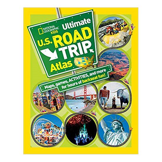
National Geographic Kids Ultimate U.S. Road Trip Atlas by Crispin Boyer
$9.99
Out of stock
Shipping calculated in cart/checkout: Shipping rates for first items start at $7, calculated based on weight of total order.
A state-by-state road atlas for kids from National Geographic. 128 pages of colorful maps, fun facts, roadside attractions, and boredom-busting games for all 50 states and Washington, D.C. Designed for the backseat, but good enough that adults stop to look, too.
- 128 pages, paperback, approx. 10" x 8.5", 15 oz
- All 50 states plus D.C. covered with easy-to-read road maps
- Games, quizzes, and seek-and-find activities for long drives
- State facts, roadside attractions, and top things to do in each state, including South Dakota
- By Crispin Boyer; published by National Geographic Kids
- Proceeds support education, conservation, and visitor services at BHPFA partner parks and forests.
Out of stock
National Geographic Kids Ultimate U.S. Road Trip Atlas by Crispin Boyer
$9.99
Out of stock
Shipping calculated in cart/checkout: Shipping rates for first items start at $7, calculated based on weight of total order.
A state-by-state road atlas for kids from National Geographic. 128 pages of colorful maps, fun facts, roadside attractions, and boredom-busting games for all 50 states and Washington, D.C. Designed for the backseat, but good enough that adults stop to look, too.
- 128 pages, paperback, approx. 10" x 8.5", 15 oz
- All 50 states plus D.C. covered with easy-to-read road maps
- Games, quizzes, and seek-and-find activities for long drives
- State facts, roadside attractions, and top things to do in each state, including South Dakota
- By Crispin Boyer; published by National Geographic Kids
- Proceeds support education, conservation, and visitor services at BHPFA partner parks and forests.
Out of stock
Real USPS rates, no markup. The money we save funds trail crews and internships.
Join BHPFA for $30 a year -> get your code by email in seconds. -> Use it at checkout today. Show your card at hundreds of nonprofit park stores nationwide for 10% off.
Every item is selected or approved by rangers and staff. Your purchase keeps them on the front lines.
Real USPS rates, no markup. The money we save funds trail crews and internships.
Join BHPFA for $30 a year -> get your code by email in seconds. -> Use it at checkout today. Show your card at hundreds of nonprofit park stores nationwide for 10% off.
Every item is selected or approved by rangers and staff. Your purchase keeps them on the front lines.
Description
About this atlas
The National Geographic Kids Ultimate U.S. Road Trip Atlas is a 128-page children’s atlas written by Crispin Boyer and published by National Geographic Kids in 2012. It covers all 50 states and Washington, D.C. with road maps designed to be readable by kids, alongside National Geographic’s signature photography and a substantial collection of games and activities aimed at making long drives less miserable for everyone in the car.
The atlas does two things well: it gives kids a real sense of what’s in each state (state symbols, notable landmarks, weird roadside attractions) and it gives them something to do while the adults drive. The seek-and-find activities, quizzes, and car games are integrated into the state pages, so the atlas works as both a reference and an activity book. Reviewers consistently note kids reading through all 50 states on their own, which is about the best thing you can say about a reference book aimed at 8- to 12-year-olds.
BHPFA carries this atlas at the Wind Cave National Park visitor center bookstore. South Dakota has its own state section, which covers Wind Cave National Park, the Black Hills National Forest, and the broader Black Hills region. If you’re visiting Wind Cave and planning your route into the rest of South Dakota, this atlas is a practical tool for the drive.
What’s inside
- Road maps for all 50 states and Washington, D.C., plus a full U.S. overview map
- State facts and state symbols for each state
- Top five cool things to do in each state (curated by National Geographic Kids editors)
- Roadside attractions: weird, funny, or unusual stops along the way
- Boredom busters: games, word searches, true/false quizzes, and seek-and-find activities throughout
- National Geographic photography on every spread
- Answer key for games and quizzes
- Comprehensive index
Specifications
- Pages: 128
- Dimensions: Approx. 10" x 8.5"
- Weight: 15 oz
- Binding: Paperback
- Publisher: National Geographic Kids
- Author: Crispin Boyer
- ISBN-13: 978-1-4263-0933-5
- Published: March 13, 2012
- Age range: 8-12 years (grades 3-7)
Who is this for?
Families taking road trips through the Black Hills and beyond. If you’re driving from Wind Cave into the rest of South Dakota or heading west through Wyoming, your kids will have a dedicated state page in front of them with the actual road map and things to look for along the way. The atlas earns its keep on road trips where you’ll actually cross state lines.
Kids ages 8-12 who are interested in geography or just need something to do in the car. The activities are genuinely varied: it’s not just word searches. The true/false quizzes on state facts are the kind of thing a curious kid will work through on their own, not just during the drive.
Parents looking for a travel gift that has shelf life. At $9.99 it’s an inexpensive addition to a road trip kit, and it’s reusable. A travel journal or road trip bingo card goes stale; a state atlas stays relevant until they’ve visited all 50 states.
Frequently asked questions
What age is this atlas designed for?
The recommended age range is 8 to 12 years (grades 3-7). That said, younger kids who are strong readers can use it, and parents often find themselves reading along. The maps and photographs are clear enough to be useful at younger ages; the games require reading comprehension.
Does the atlas include South Dakota and the Black Hills?
Yes. The atlas covers all 50 states with a dedicated spread for each. South Dakota’s section includes road maps and coverage of Wind Cave National Park, the Black Hills National Forest, and regional attractions. If you’re visiting Wind Cave and planning the rest of your South Dakota trip, the atlas gives kids a way to follow along and understand where they’re going.
How is this different from a standard road atlas?
A standard road atlas (Rand McNally, AAA) is designed for navigation: dense highway maps, exit numbers, distance tables. This atlas is designed for exploration and entertainment. The maps are clear and accurate for orientation, but the bulk of each state spread is devoted to what’s worth seeing and doing there. It’s the difference between a navigation tool and a travel companion.
Is there a 2nd edition?
Yes. A 2nd edition was published in 2020 with updated content and 144 pages. BHPFA carries the 1st edition (2012, 128 pages). If the 2nd edition becomes available, it will carry a different ISBN (978-1-4263-3703-1). The core format is the same across both editions.
Does buying this support national parks?
Yes. BHPFA is the official nonprofit partner of Wind Cave National Park, Jewel Cave National Monument, Scotts Bluff National Monument, and Agate Fossil Beds National Monument, as well as the Black Hills National Forest and Nebraska National Forests and Grasslands. Proceeds from every purchase support education programs, conservation projects, and visitor services at these sites.
Where is this sold?
BHPFA carries it at the Wind Cave National Park visitor center bookstore and online at blackhillsparks.org. It is also sold at national bookstores and through National Geographic’s distribution channels.
Is this a good gift for a child who hasn’t been to many national parks yet?
Yes, and that’s probably the most common use case. The atlas is organized so kids can flip to any state and learn what’s there before visiting. For a child who hasn’t traveled much yet, going through the atlas state by state is a way to build a mental map of the country and start a wish list of places to visit. Several reviewers note kids reading through the entire book on their own, not just during road trips.
Every Purchase Makes a Difference
When you shop with Black Hills Parks & Forests Association, you are directly funding:
- Education programs — nature workshops, Junior Ranger activities, and homeschool adventures for kids across the Black Hills
- Trail maintenance — keeping hiking trails safe and accessible at Wind Cave, Jewel Cave, and the Black Hills National Forest
- Visitor services — park store operations, interpretive programs, and the staff who help millions of visitors each year
- Conservation — supporting the long-term health of public lands in the Black Hills and Nebraska
BHPFA is the official nonprofit partner of the National Park Service and U.S. Forest Service in the Black Hills region. We have supported these public lands since 1946.
Additional information
| Weight | 15 oz |
|---|---|
| Brand | National Geographic |
| Pages | 128 |
| Binding | Paperback |
| ISBN | 9781426309335 |
| Publisher / Manufacturer | National Geographic Kids |
| Year Published | 2012 |
| Dimensions | Approx. 10" x 8.5" |
| Weight | 15 oz |
| Age Range | 8-12 years |
Note on International Orders
Some countries charge import duties, VAT, or handling fees on delivery. These are set by your local government and are not included in our checkout total. Customers are responsible for paying any such charges before receiving their package.