
Black Hills Topographic Map by National Geographic – Waterproof & Tear-Resistant
$14.95 – $24.95
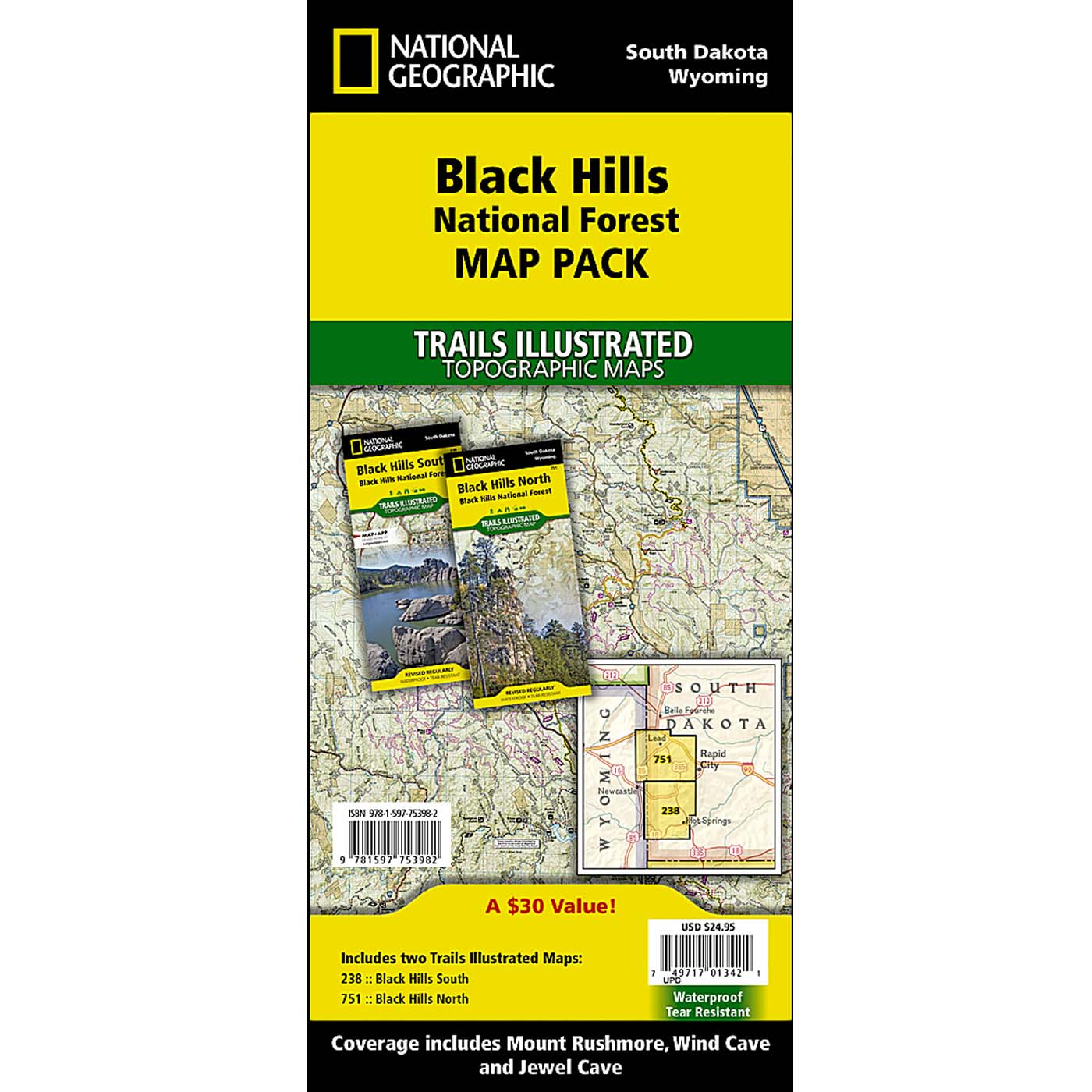
Combo Pack:
Explore both the North and South Black Hills with this waterproof, tear-resistant Map Pack Bundle. 15% discount!
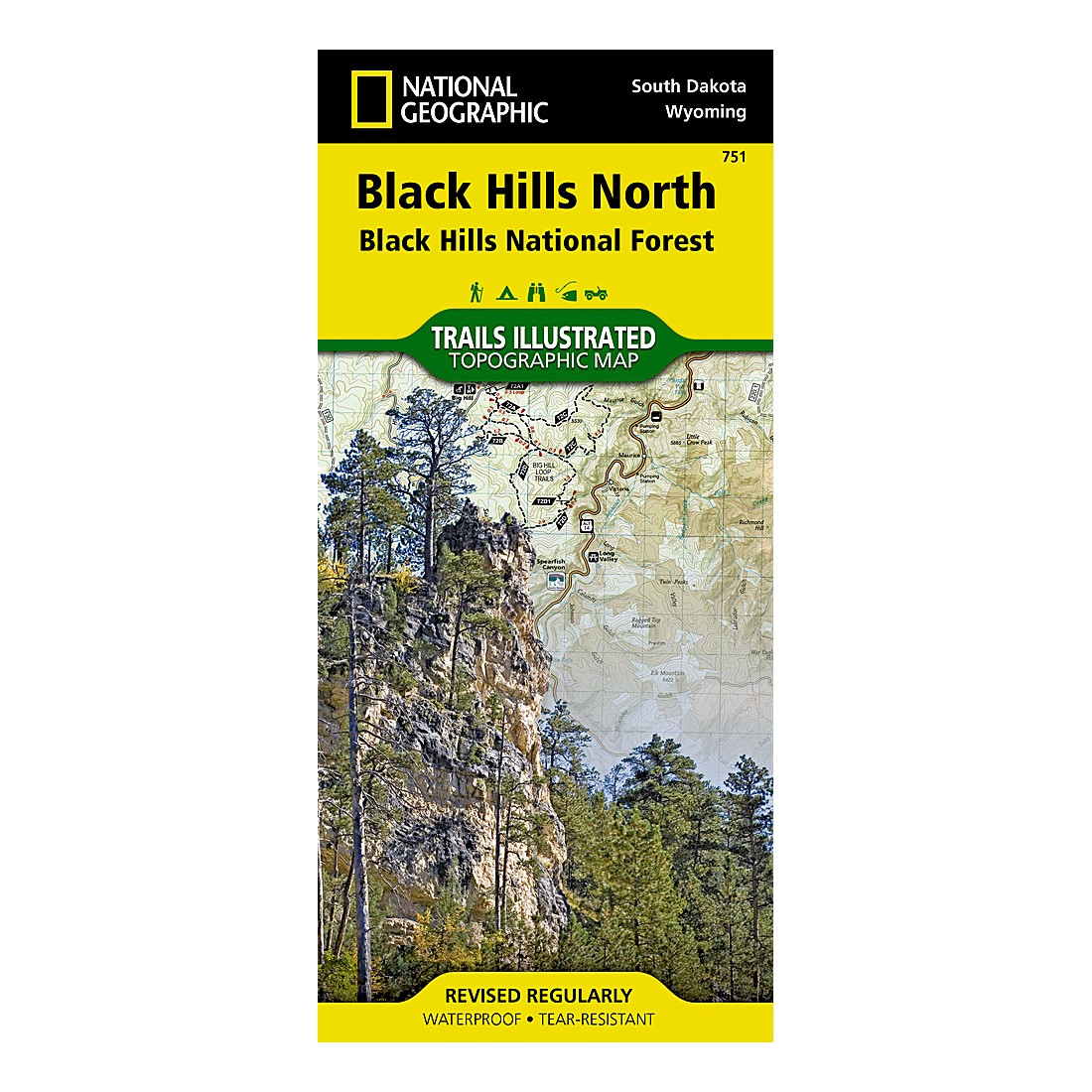
Black Hills North Map:
Covers iconic spots like Roughlock Falls, Pactola Reservoir, and Spearfish Canyon, plus hundreds of trail markers and points of interest.
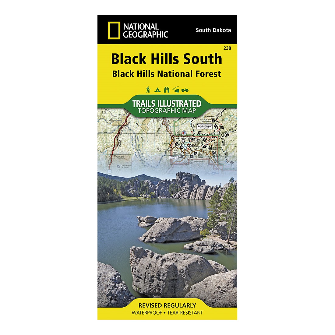
Black Hills South Map:
Includes popular sites like Mount Rushmore, Wind Cave National Park, and Jewel Cave National Monument.
|
|
|
|


Everything in the online park store is ranger-reviewed for accuracy, cultural inclusivity, and to enhance your connection to the park or forest’s educational message. Net proceeds of all BHPFA sales go to “Wonder & Exploration” at our NPS and USFS partners!
Discover Hidden Trails and Unforgettable Adventures in the Black Hills
Unlock the natural wonders of the Black Hills National Forest with the Black Hills Topographic Maps from National Geographic—your trusted guide for rugged exploration. These expertly crafted, waterproof, and tear-resistant maps are made to endure the elements, whether you’re trekking through rain-soaked trails, navigating rough terrain, or exploring remote, off-grid areas where cell service fails. Available as a Combo Pack or as individual maps for the North or South regions, each map is packed with detailed, up-to-date trail information, ensuring that your adventure is safe, informed, and full of discovery.
Navigate with Confidence
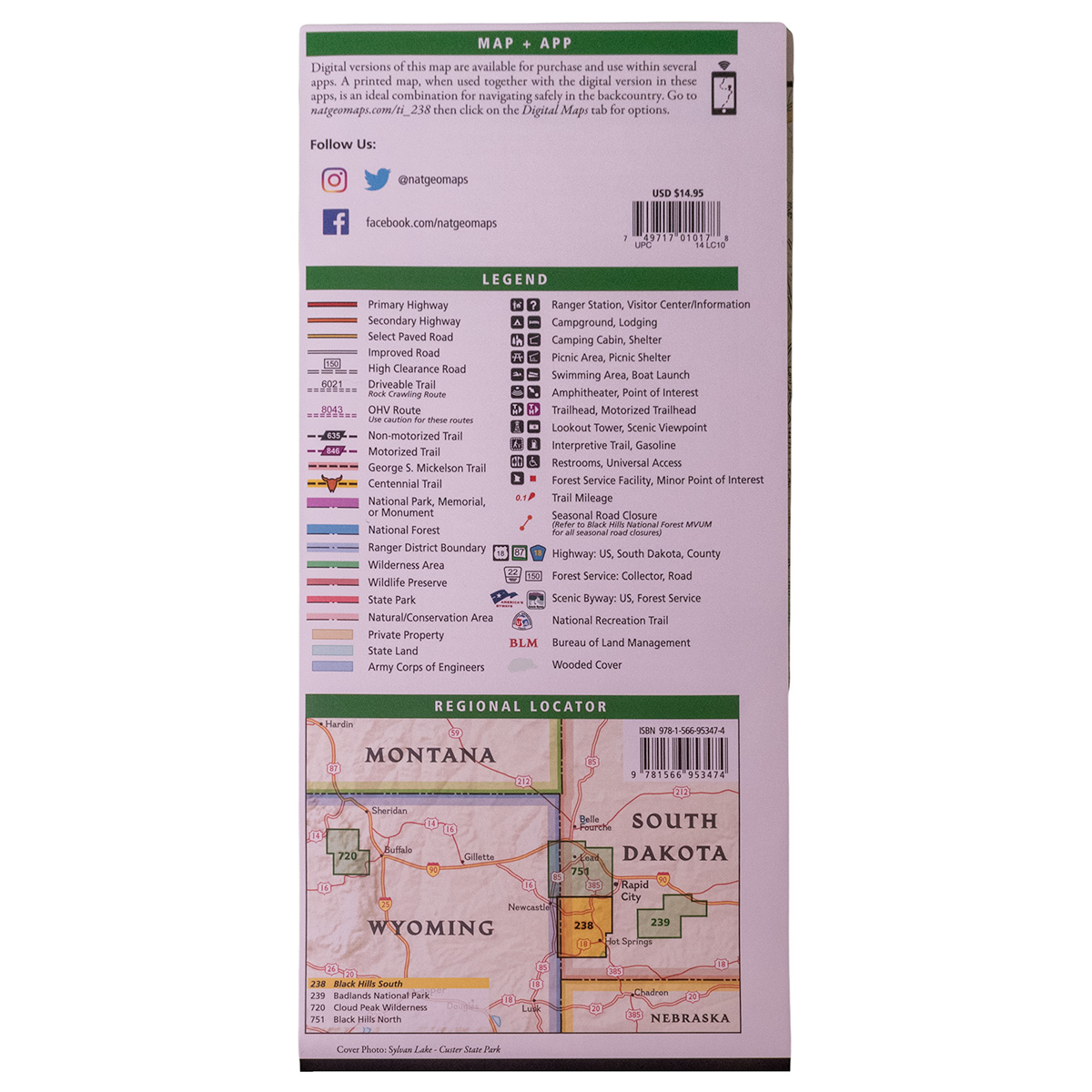
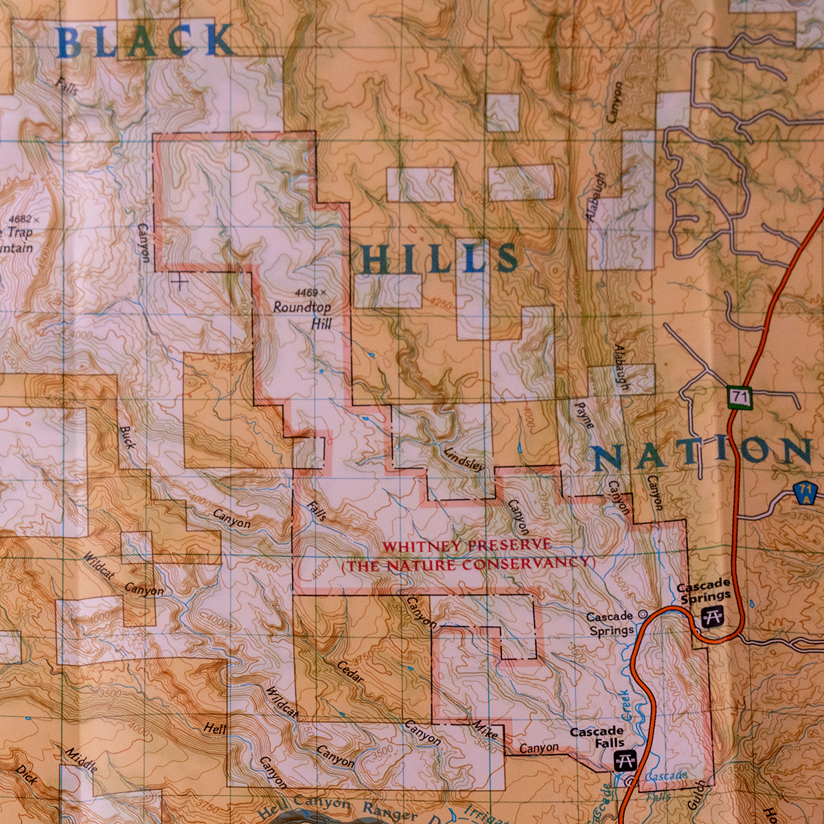
Designed in collaboration with the U.S. Forest Service, these maps offer more than just basic trail guidance. They include precise mileage markers, trailhead locations, and cover hundreds of points of interest, including scenic lookouts, campsites, and boat ramps. You’ll also find background info on popular sites like Mount Rushmore, Wind Cave National Park, and Spearfish Canyon Scenic Byway.
- Black Hills North Map highlights incredible spots like Roughlock Falls, Pactola Reservoir, and the Beaver Creek Trail System.
- Black Hills South Map guides you through gems like Custer State Park, Jewel Cave National Monument, and the George S. Mickelson Trail.
With the UTM grid for GPS navigation, even if your smartphone loses signal, you’ll have the confidence to explore safely in areas where digital maps can’t reach. These physical maps are your most reliable companion when deep in the wilderness—helping you stay on course no matter what challenges nature throws your way.
Why Physical Maps Matter for Off-Grid Adventures
In remote areas of the Black Hills, cell service is unreliable, making GPS and mobile maps useless in critical moments. That’s where National Geographic’s Black Hills Topographic Maps come to the rescue. With Backcountry Tough paper that resists both tears and water, these maps are durable enough to survive rainstorms, rugged trails, and constant folding. They offer something a digital map simply can’t—durability, reliability, and the peace of mind that comes from knowing your map won’t fail when your tech does. Whether you’re an experienced hiker, an off-road enthusiast, or a casual adventurer, these maps will guide you through every trail, ensuring you make the most of your time in the Black Hills.
Check out our other maps and trail guide books to get even more “reception proof” confidence on the trails.
Combo Pack: Your Complete Guide to the Black Hills
Explore both the northern and southern regions of the Black Hills National Forest with the Map Pack Bundle—offering two essential maps at a 15% discount. With these in hand, you can confidently navigate all of the area’s must-see landmarks and hidden gems. These maps aren’t just tools—they’re invitations to adventure, helping you create memories on trails, at campsites, and in breathtaking landscapes.
Additional information
| Weight | N/A |
|---|
19 reviews for Black Hills Topographic Map by National Geographic – Waterproof & Tear-Resistant
Why do we charge shipping?
By paying the calculated USPS rate based on the total weight of your order, more of your purchase goes to supporting programs and conservation at your National Parks and National Forests.
Charlie –
Very nice!, durable, detailed and easy to read….very worth the money. I can’t wait to see how close the GPS coordinates are.
As always the shipping is fast and the handwritten “thank you” I get on my trail pass receipt is a nice thing you seldom see anymore.
Todd Ossenfort –
Exactly what I was looking for!!
The maps are awesome.
Anonymous –
Very detailed. Looking forward to using it out there. Love the waterproof/tear resistance.
herbert.bruseth@hotmail.com –
Detail is great, vary pleased well worth the money.
Anonymous –
The maps are highly detailed and cover the entire Black Hills in SD and some of WY. They are large enough to be easy to read and are well marked. Distances would be nice on the roads between points of interest. Overall a great buy and for someone who wants to get off the beaten path a necessity.
Anonymous –
Durable and water resistant, I was looking for a map that would show all the camping sites in the Black Hills, these are exactly what I was hoping for. They also delineate between different types of gravel and dirt roads. They are big though, the Black Hills maps (2) are split between North section and South section and those are split again, front and back of each map. But if you want good detail these are it.
Jana –
Good topo maps. I have the Garmin topos on my GPS, but it really helps me to see the big picture. Plus there’s always the chance of even my back-up batteries going bad.
Shawn –
Bought this map for Elk hunt in the Hills.
Very detailed and laminated will help with the moisture. Came in a timely manner. Would recommend to anyone needing detailed map.
Susan –
Many years ago I used to spend time riding horse in the Black Hills. I want to return, now, to camp in my little travel trailer and to hike and see all the little corners I didn’t see before. These maps are a great help!
Anonymous –
Great map, but a lot of the hiking trails don’t have mileage, so you don’t know distances. Was really hoping this map would have mileage.
Paul –
Excellent topo map. Loaded with information! Water proof and tear resistant. Awesome! Super fast delivery!
I cannot wait to get there next month and have these maps with me.
Jake Drobnick –
Only way to improve on these maps is to have the same color coordination as the GPS download. If the same colors, markings were used on all map formats, it would make things a little easier to navigate.
Overall, great maps. Arrived quickly!
PKA –
I ordered the map because the website claimed it was a better map than the National Forest map however it did not include the area I was interested in, the Black Hills portion in Wyoming. My mistake there I guess, but I assumed a Black Hills map would cover all of it. It is a very good quality map for the price. Maybe I can use it sometime in the future
tad –
Do you have any suggestions on where to start looking for a good turkey spot. We are staying in hill city, the maps are a good start but wow so much area. I know this is a long shot for any info or help but worth a try since we are traveling 1200 miles.
Keith Hemmelman –
I’ve hunted in the Black Hills for many years in the past but the Forest Service stopped updating their maps several years ago. It was a god send to find and purchase these Trails Illustrated maps to have updated info. These maps are the ‘slippery’ kind of paper that is more durable and they are quite large with all the topo shading, roads, and trails shown. The only think missing from these maps that the Forest Service maps had was the marking of private lands so you had an idea of where not to hunt. For photography, hiking, and just general sight seeing, these Trails Illustrated maps are the best reference map you can find and are well worth the cost!
Anonymous –
great quality, with alot of detail, I know I can take them anywhere on the trail
Anonymous –
Perfect for planning a Black Hills hunting, camping, or hiking trip. Camp ground locations, land marks, and roads are well marked. Great price for two colored maps that are easy to read. Shipping was quick as well, took less than 5 days from when I ordered.
Doug Lex Luther –
Wow, planning on a turkey hunting trip in spring 2013 and this will make it the easiest trip to preplan locations with evening hillside perches and daytime fields near canyon creeks and water.
Gary –
Very helpful maps, and outstanding service from the customer service folks behind the web site. They noticed an error on my part and saved me money.